


The terroirs of the Cognac region
The terroirs of the Cognac region are located on the southwestern plains of the Aquitaine Basin. This land with sedimentary soils has formed two main types of terroirs as well as a multitude of micro-environments with conditions that are more or less suitable for winegrowing.
The Aquitaine Basin’s sedimentary layers overlay the Armorican Massif and the Limousin mountains and sweep gradually down towards Southwest France. Their outcrop in the Charentes region is slightly sloped (south-east/north-west). They were affected by north-west/south-east Hercynian deformations during the Paleozoic Era and east-west deformation during the Tertiary period with the emergence of the Pyrenees. The movements of the earth’s crust are visible in the syncline of Saintes-Châteauneuf and in the anticline of Saintonge-Jonzac-Brouage. This anticline breaks through the most recent sedimentary layers along a south-east/north-west axis. The oldest Cenomanian layers in the center consist of clay, sand and calcareous sandstone, which create different terroirs. The same soils can be found on either side of the tectonic structure, including chalk from the Cretaceous period.
The doucins of Saint-Palais de Phiolin
This specific terroir is characterized by soil referred to as doucins, which contains Cenomanian sandy clay and calcareous sandstone from the Saintonge anticline.
Within the sedimentary soils, thick layers of limestone with varying degrees of resistance are interlaid with clay and sand. Marine sedimentation stopped near the end of the Cretaceous period (60 million years ago), whereas the continental deposits that descended from the Limousin region ended during the second half of the Tertiary period (10 million years ago).
During the first half of the Tertiary period, the tropical and semi-arid climates altered the surface layers, resulting in induration phenomena, the occurrence of flint nodules, and crust deposits on the limestone caused by the migration of silica and iron oxides. The hot, humid climates modified and eroded the crystalline bedrock, which mixed with the detrital input that descended from the Limousin region in the form of vast fans covering the majority of the marine sedimentary soils. Near the end of the development cycle for the rises sloping towards the West, erosion removed the majority of the sand, leaving only fine clay particles at the bottom and coarser particles at the top. The gradual decline in rainfall led to differential erosion and a more concentrated hydrographic network.
The Quaternary period was marked by four successive glacial periods and milder interglacial periods before the emergence of the current climate around 15,000 BCE. The approximately 100-meter drop in sea level during the glaciation periods and subsequent rise during the Holocene glacial retreat caused the marks of submergence that are visible on the coastlines and estuaries, and the sand and silt deposits on the foreshore during low tides that was carried off by westerly winds.
The gutters in Charente and Garonne-Gironde became well-defined at the end of the Tertiary period. The valleys were deepened through Hercynian and Pyrenean deformations in the earth’s crust and sediment layers, leaving behind more resistant soils (limestone, sandstone). During the glacial phases, soft soils were hollowed out and depressions developed. Alternating periods of low and milder temperatures reduced the occurrence of slaty limestones on the surface and the formation of grèzes (stratified deposits) that run along the slopes. The abundance of these deposits softened the landforms, which explains the streamflows (the Charente River no longer meandered in Mainxe). The valleys featured a succession of nested terraces and alluvial deposits. Aeolian sand was deposited near the coastlines just as the Halocene glacial retreat was starting to deposit clayey sand known locally as “bri”.
Two main terroirs…
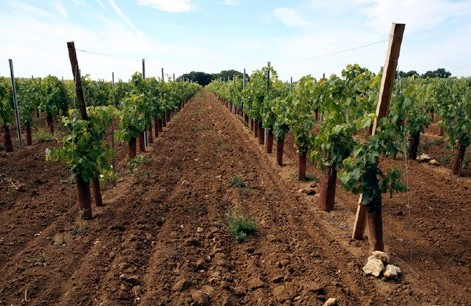
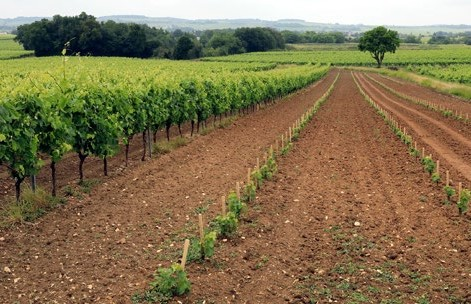
The terroirs of the Charente vineyards can be divided into two types: champagne and a type of limestone known locally as groie. The Charente Valley forms the southern limit of the groie soils, with the champagne soils covering the majority of the Charente vineyards, besides the residual clay-siliceous deposits from the Tertiary period located on the highest points. Groie soils are found on hard limestone from the Jurassic period and certain Cretaceous stages (Turonian and Coniacian). These light, fairly thin and stony soils contain brown and reddish clay resulting from decalcification. They have low active limestone content. Groie soils cover the low plateaus and are highly permeable due to an abundance of slabs and their thinness. They heat up quickly in the sun. Groie terroirs can be divided into three types based on their clay and stone content.
The Campanian terroir in Grande Champagne
This terroir features highly eroded champagne soil from which small chalky pieces emerge.
Mainxe Groie terroirs These terroirs are formed by Turonian and Coniacian sediments that strengthen the backslope of the cuesta.
The heathlands of Montmorélien
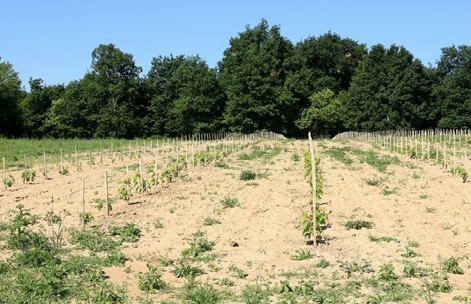
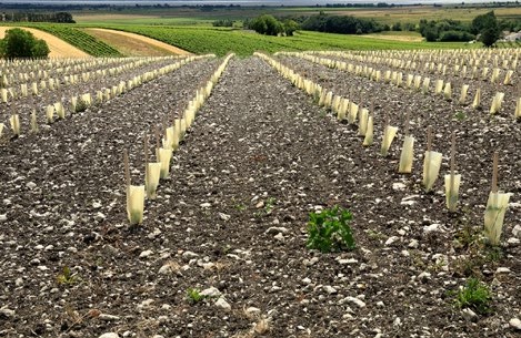
On the slopes of Sud-Charente, the clay-siliceous soil located at an altitude of 146 meters contains doucins that become powdery during the summer. New vines have been planted in the clearings there.
The Campanian terroir in Saint-Dizant-du-Gua
Small ripples of Campanian chalk are now covered with young vines. This soil, which also contains small stones, is characteristic of the champagne soils. They are predominant in the Gironde Estuary and marshland.
The skeletal groie soils, referred to as “lunar” soils by some winegrowers from Borderies and Grande Champagne, contain an abundance of large stones in the layers of Coniacian and Turonian sediments. The extremely dry soils, scorched by the summer sun, produce a limited wine yield. Stony groie and small groie soils contain clay resulting from decalcification that is thick and more or less powdery during the summer. They contain numerous hard stones that are difficult to crush. The limestone they contain is relatively inactive. These highly permeable soils can be found in the layers of Portlandian and Kimmeridgian soils. These groie soils cover vast expanses stretching north of Angoulême and Matha up to Aulnay and La Rochelle. These deeper and solid groie soils contain fewer stones and are found near the bottom of slopes. They are rich in clay and contain more plentiful water reserves.
The “lunar” soils southeast of Cherves-Richemont
The hillocks that rise from the lowlands to nearly 40 meters in altitude are composed of hard limestone from the Coniacian and Turonian stages. The groie soils are skeletal, relatively thin, and contain very hard stones that are difficult to work with. The vines are able to find the water reserves they need to grow.
Lowlands with clay soil
At altitudes ranging between 10 and 20 meters, the Portlandian soil contains a high clay content with difficult drainage despite the presence of limestone gravel at greater depths. A slight slope stretches down toward a tributary of the Antenne. The lowlands are sensitive to frost in the spring.
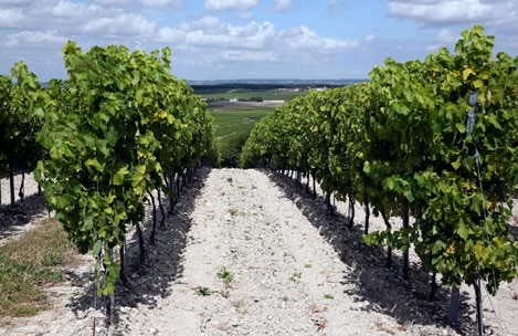
The Champagne terroirs, which are unique in the world, developed on chalky soil from the Campanian and Santonian stages. The darker and lighter grey soil is mixed with numerous fragments of soft, chalky limestone. Located at altitudes ranging between 60 and 120 meters, the haute-champagne terroirs formed atop layers of Campanian chalk that are over 200 meters thick. They often hold a dominant position, become whitish due to erosion caused by heavy summer thunderstorms, and contain a high active limestone content. These thin layers of soil cover a brittle limestone subsoil, allowing the vine roots to sink several meters deep, which protects them from severe droughts.
Cognac from Grande Champagne has an aging potential exceeding that of other wine spirits from the Cognac appellation. At a lower altitude, the basse-champagne terroirs formed by Campanian and Santonian soils are thicker and contain less slaty limestone. They do not dry out as well in the depressions of Gensac, Bouteville, Pérignac and Jarnac-Champagne. On the Borderies plateau, Santonian chalk can be found at over 60 meters in altitude, partially covered by layers of thin continental clay from the Tertiary period.
The wooded champagne terroirs can be found in clearings located south of Charente. Southeast of Jonzac and Barbezieux, in Montmoreau and Montguyon, the softwood forest lies atop residual clay-siliceous deposits located on the highest points. On the slopes, vines grow on grey and whitish soil. The champagne terroirs also stretch along the banks of the Gironde River. Campanian soil can again be found on the western slope of the Jonzac- Brouage anticline thanks to carved chalky knolls. To the west, the soils that often contain aeolian sand are less sticky and produce Cognacs with generous aromas and flavors.
… and diverse micro-terroirs
Doucins, continental sand, aeolian sand, varennes and grèze (scree) soils form just a few of the micro-terroirs that are more or less conducive to winegrowing in the Charentes countryside. Located on the heights classified as part of the mainly wooded Brandes site, the terroirs formed by fragments of the rises from the Tertiary period contain sand, gravel and river stones. They receive higher rainfall, which creates a water reservoir that flows slowly down towards the slopes of the Champagne vineyards. Just below this area, doucins can be found on wet plots covered with boggy patches during the winter, which are often in contrast with the underlying chalky layers.
They then dry out during the summer and become powdery. The land that developed atop Cenomanian sandy clay located in the middle of the Saintoge anticline and along the Burie-Angoulême axis is similar to the doucins in terms of potential.
The varennes and grèze soils can be directly linked to the effects of the last paleoclimates of the Quaternary period. The limestone gravel was formed by the erosion of the bordering plateaus and was moved about by the many rivers that existed during the wet paleoclimate periods. These deposits that were rearranged by flowing water also accumulated in depressions, including a thick layer that developed in Thors, and those in the terraces in the Antenne valley, and the waterways of the Antenne catchment area. They also produced unique terroirs in the Borderies. The recent alluvial sediments found in the valleys are not very conducive to high-quality wine production.
© Michel Guillard